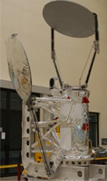
Micro-Wave Radiation Imager-I (MWRI-I)
Description
MWRI-I is a conical scanning microwave imager at five frequencies with dual polarizations (10 channels). The sensor measures microwave emission from land and ocean surfaces, and also from precipitation and water vapor in the atmosphere.
The microwave wavelength is much longer in the electromagnetic spectrum compared with visible and infrared wavelength, and at some channels the wavelength is longer than 1 mm, the imager can penetrate the clouds, providing an all-weather measurement capability. At higher-frequency channels, such as 89 GHz, the scattering signature from the cloud and precipitation are also good indicators for detecting rainfall over land and ocean. The spatial resolutions are from 12 to 80 km, depending on the wavelengths.
Unlike other on-orbit microwave radiometers, MWRI of FY-3 is designed to have an end to end calibration system. The radiation from the earth and from the warm/cold calibration target are reflected to receivers by the same reflector, so that it needs no antenna correction.
MWRI-I provide us information of land surface temperature, soil moisture, snow depth, sea ice concentration, sea surface temperature, precipitation rate, cloud water, and ocean surface wind speed. MWRI's observations can also be used in numerical weather prediction models, making our weather forecast more accurate.
| Satellite | FY-3A , FY-3B , FY-3C , FY-3D |
|---|---|
| No. Channels | 10 |
| Dynamic range | 3~340K |
| No. sampling points | 240 (FY-3A) / 253 (FY-3B, FY-3C) / 266 (FY-3D) |
| Quantification grade | 12 bit |
| Main-beam efficiency | ≥90% |
| Channel registration | Pointing errors <0.1° |
| Scanning mode | Conical scanning |
| Width | 1400km |
| Antenna perspective (°) | 45±0.1 |
| Scan cycle (s) | 1.7±0.1 (FY-3A) / 1.8±0.1 (FY-3B, FY-3C) / 2.0±0.1 (FY-3D) |
| Scan error (ms) | 0.34ms (adjacent scan line) / 1ms (continuous in 30 minutes) |
| Weight | 175kg |
| Power | 125W |
Characteristics
| Frequency (GHz) | Polarization | Bandwidth (MHz) | Sensitivity (K) | Calibration accuracy (K) | Ground resolution (km×km) |
|---|---|---|---|---|---|
| 10.65 | V.H | 180 | 0.5 | 1.0 | ≤51×85 |
| 18.7 | V.H | 200 | 0.5 | 2.0 | ≤30×50 |
| 23.8 | V.H | 400 | 0.8 | 2.0 | ≤27×45 |
| 36.5 | V.H | 900 | 0.5 | 2.0 | ≤18×30 |
| 89 | V.H | 2×2300 | 1.0 | 2.0 | ≤9×15 |
| 150 | V.H | 2×1500 | 1.3 | 2.0 | ≤7.5×12 |
Data and Products
| Satellite | Instrument | Datasets |
|---|---|---|
| FY-3D | MWRI-I | L1 data |
| FY-3C | MWRI-I | L1 data, L2L3 product |
| FY-3B | MWRI-I | L1 data, L2L3 product |
| FY-3A | MWRI-I | L1 data |
Calibration and Validation
MWRI-I