FY-4 Series
Introduction
FY-4 series is China's second generation geostationary meteorological satellites. The satellite platform is three-axis stabilized to improve the time resolution of observations and regional mobility. The new generation satellites are designed with an enhanced imagery scanning capability, capable of monitoring small and medium scale weather systems. They are equipped with vertical atmospheric sounding and microwave detection capabilities to address 3D remote sensing at high altitudes. They are also equipped with solar observations for extreme ultraviolet and X-rays, in a bid to enhance China's space weather watch and warning capability.
FY-4 will be made either carrying optical or microwave instruments. An optical satellite will carry aboard a multiple channel 2D scanning imager, an interferometric vertical detector, a lightning imager, CCD camera and an earth radiation budget instrument. The satellite produces earth disc imageries every 15 minutes.
Status
| Satellite | Launch | End of Service | Status | Position |
|---|
Comparison with FY-2
| FY-4B (Operational) | FY-4A (R&D) | FY-2 (Operational) | |
|---|---|---|---|
| Platform stabilization | Three-axis stabilization | Three-axis stabilization | Spin stabilization |
| Working life in orbit | 7 years as ensured | 7 years as designed, 5 years as ensured | 3 years as designed |
| Observation efficiency | >85% | >85% | appr. 5% |
| Observation mode | Imaging, sounding and rapid imaging | Imaging, sounding and lightning | Imaging |
| Main payloads | AGRI | AGRI | VISSR |
| Band range: 0.45~13.6μm | Band range: 0.45~13.8μm | Band range: 0.55~12.5μm | |
| Spatial resolution: 0.5~4km | Spatial resolution: 0.5~4km | Spatial resolution: 1.25~5km | |
| Full disk time: 15 min | Full disk time: 15 min | Full disk time: 30 min | |
| Coverage: flexible | Coverage: flexible | Coverage: fixed | |
| GIIRS | GIIRS | N/A | |
| Band range: LWIR 700~1130cm-1, MWIR 1650~2250cm-1, VIS 0.55~0.90μm | Band range: LWIR 680~1130cm-1, MWIR 1650~2250cm-1, VIS 0.55~0.90μm | ||
| Spectrum resolution: LWIR/MWIR 0.8cm-1 | Spectrum resolution: LWIR 0.8cm-1, MWIR 1.6cm-1 | ||
| Spatial resolution: IR 12km, VIS 1km | Spatial resolution: IR 16km, VIS 2km | ||
| Time resolution: 45 minutes | Time resolution: 1 hour | ||
| GHI | N/A | N/A | |
| Band range: all color, 0.445~12.5μm | |||
| Spatial resolution: 0.25~4km | |||
| Temporal resolution: <1 min (2000km×2000km) | |||
| N/A | LMI | N/A | |
| Band: 777.4±0.5nm | |||
| Spatial resolution: 7.8km | |||
| Coverage: China and surroundings | |||
| SEP | SEP | SEM | |
| Particles, magnetic field | Particles, magnetic field | Particles |
Instrument
Observing instruments onboard FY-4:
- Advanced Geostationary Radiation Imager (AGRI). The instrument has atleast 14 channels with a spectral range set between 0.55μm and 13.8μm.
- Geostationary Interferometric Infrared Sounder (GIIRS).
- Lightning Mapping Imager (LMI). Tis instrument is optional.
- Geostationary High-speed Imager (GHI). Tis instrument is optional.
- Space Environment Package (SEP).
- Solar X-EUV imaging telescope (SXEUV).
Compared with similar satellite worldwide:
| FY-4B (China) | FY-4A (China) | GOES-R/S (USA) | MTG-I+S (EU) | Himawari-8/9 (Japan) | ||
|---|---|---|---|---|---|---|
| Imaging | Spatial resolution | 0.5~4km GHI: 0.25~2km |
0.5~4km | 0.5~2km | 0.5~2km | 0.5~2km |
| Temporal resolution | Full disk: 15 min GHI: 1min |
Full disk: 15 min | Full disk: 5 min | Full disk: 10 min | Full disk: 10 min | |
| No. bands | 15 GHI: 7 |
14 | 16 | 16 | 16 | |
| Sounding | Spectrum range | LWIR: 680~1130cm-1 MWIR: 1650~2250cm-1 |
LWIR: 700~1130cm-1 MWIR: 1650~2250cm-1 |
N/A | LWIR: 700~1210cm-1 MWIR: 1600~2175cm-1 |
N/A |
| Spectrum resolution | <0.8cm-1 | 0.625cm-1 | 0.625cm-1 | |||
| Spatial resolution | 12km | 16km | 4km | |||
| Temporal resolution | 45 minutes | 1 hour | 1 hour | |||
| Lightning | N/A | Central wavelength: 777.4nm Time resolution: 2ms |
Central wavelength: 777.4nm Time resolution: 2ms |
N/A | N/A | |
| Space | Particles/magnetic field | Particles/magnetic field | Particles/magnetic field/Solar imaging | N/A | N/A | |
Products
| Satellite | Datasets |
|---|---|
| FY-4A | FY-4A datasets |
| FY-4B | FY-4B datasets |
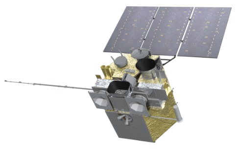
FY-4A satellite
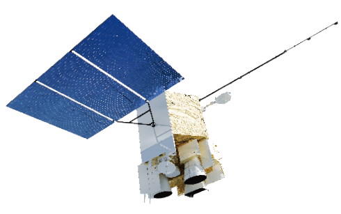
FY-4B satellite