Outline of GEO System
FENGYUN GEO GROUND APPLICATION FACILITIES
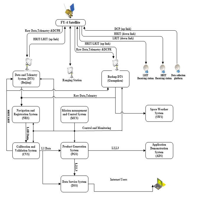
The FY geostationary ground system consists of: a Command and Data Acquisition Station (CDAS); a Data Processing Centre (DPC); a Satellite Operation Control Centre (SOCC); Ranging Stations (one primary station, three secondary stations including one in Australia), widely dispersed Data Collection Platforms (DCP); Medium-scale Data Utilization Stations (MDUS) and Small-scale Data Utilization Stations (SDUS); and a Ground Communication System, etc.

The tasks of FY-GEO ground system are as follows:
- Receive day and night cloud, water image data from Fengyun geo-satellites;
- Produce a variety of images and products after processing by DPC;
- Receive and distribute observation data collected by DCPS;
- Broadcast observation data to users;
- Extract the information of solar protons and other particles from telemetry data stream for space weather service;
- Satellite mission control, and satellite status monitoring.
COMMAND AND DATA ACQUISITION STATION (CDAS)
The CDAS is located in the western suburbs of Beijing
(116o16'34"E, 40o03'03"N)
The CDAS consists of antenna,
receiver, transmitter, telemetry, command and synchronous data
buffers (S/DB) etc.

The main tasks of the CDAS are as follows:
1. Receiving
raw data with bit rate of 14 Mbps by the antenna;
2.
Transmitting stretched VISSR data in HRIT format;
3.
Transmitting command signals to FY-2 satellite;
4.
Receiving telemetry (including SEM) data;
5.
Transmitting and receiving ranging signal;
6. Receiving
Data Collection Platform reports from platforms.
DATA PROCESSING CENTER (DPC)
The DPC is for satellite data processing, archiving and product distribution. It consists of main computers, communication controller local network, a series of large capacity disk and peripheral devices.
The tasks for the Data Processing Centre are:
1.Satellite Remote Sensing Data Processing:
The raw
image data received in real-time by CDAS is converted to the
stretched image through S/DB in CDAS.
Telemetry and
trilateral ranging data received by CDAS is transmitted to DPC,
where the satellite orbit and attitude are calculated and
predicted. Image calibration and location calculation are
completed to support the work of Satellite Control Centre and
remote sensing products processing. The SEM data are also
processed in real time;
Various kinds of remote sensing
products are derived from S-VISSR image data.
2. The
data processing of the data collection platform (DCP);
3. The data processing of SEM;
4. On-line and off-line
archiving of the various kinds of remote sensing products;
SATELLITE OPERATIONAL CONTROL CENTER (SOCC)
The Satellite Operational Control Center(SOCC) is responsible for operational monitor and control of FY-GEO system. The major functions of SOCC are as follows:

- Operational control and schedule: making operational schedule, issuing sending command to FY geo-satellite, monitoring and scheduling ground application system;
- Telemetry data processing, image quality monitoring and analysis;
- Real time data monitoring and displaying.